How Travelers Found Their Way Before Road Atlases
How travelers found their way before road atlases depended on maps, signs, local directions, and landmarks—a method that still helps make western routes clearer.
Before road atlases became common, travelers pieced routes together from regional maps, road signs, local directions, and landmarks they could recognize. Those sources worked best in combination: a map showed the road network, a sign confirmed a junction, and a distinctive place on the ground helped travelers know they were on course.
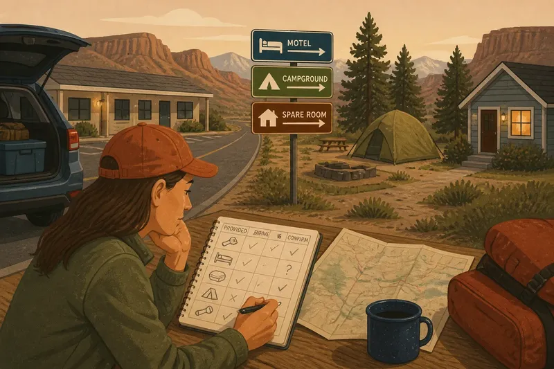
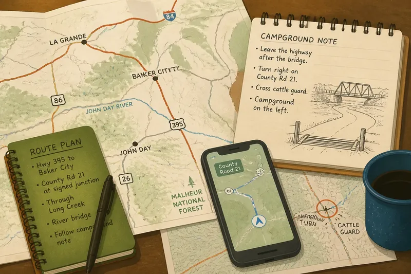
Say Maya is planning an invented drive from a small town in eastern Oregon to a campground near the John Day River. She has a regional road map, a phone with offline maps, and a campground note that describes the final turn by mentioning a bridge and a cattle guard. Her route follows a state highway before joining a county road, where phone reception may be limited.
Her tools do not give identical directions. The map shows connections between towns, signs name roads and destinations, and the campground note describes nearby features. Maya can compare those clues instead of treating any single one as the whole route. That is the practical value of the older method: each source answers a different question.
Maps and route choices
A road map helps travelers choose a corridor, or the general chain of roads between places. Its scale determines how much ground appears on the page and how much detail is visible. A regional map makes it easier to compare highways and towns, while a more detailed county map can show smaller roads and junctions.
A line that looks direct on a regional map may pass through a junction, a mountain pass, or a long stretch without services. A closer map reveals more local detail but may not show how that road fits into the broader trip. Travelers using printed maps learned to move between these views: first choose the general corridor, then inspect places where a turn or road change matters.
Maya traces the route from her starting town to a larger junction, then checks that the county road appears on her detailed map. She marks the town where she expects to leave the state highway. Those marks give her a way to compare the planned route with road names and destination signs as she travels.
Road signs and directions
Road signs offer shared references that drivers can check for themselves. Route numbers, road names, and destination signs can confirm a turn without relying on someone’s memory of spoken instructions. In rural areas, a local direction may use a community name that does not appear prominently on a map, so comparing it with nearby signs can help resolve uncertainty.
Older directions often connected an action with a visible feature: turn after a bridge, continue past a store, or stay on the paved road toward a named community. A landmark can be ambiguous, and a sign may be easy to miss if the traveler has no reason to expect it. Pairing a landmark with a road name or route number makes the direction easier to check.
Maya’s campground note says to leave the highway after the bridge, but her map shows two bridges in the area. She checks the county-road name and looks for a sign at the junction before turning. The bridge remains a clue, not the sole instruction. If the sign and map do not match the note, she can stop somewhere safe and ask for clarification rather than guess.
Landmarks and memory
Landmark-based navigation means remembering a route through recognizable features and the actions associated with them. A traveler might recall crossing a named river, passing a town entrance sign, and turning at a marked junction. This sequence can be easier to recall than a long string of road names.
Distinctive landmarks are more useful than generic ones. A bridge over a named river gives more context than “the next bridge.” But landmarks can change: a business may close, a sign may be hidden, and open country can look similar from one stretch to another. Linking a feature to a road name or turn helps keep the route legible if the scenery is unfamiliar.
Maya writes a short sequence beside her map: follow the state highway to the signed county-road junction; continue through the named community; watch for the river bridge; check the campground note before leaving the paved road. If the expected community does not appear, that is a reason to pause and check the map, not to keep driving on the strength of vague familiarity.
Preparing for key turns
Route preparation works best when it draws attention to decisions, not every bend. A highway exit, a fork between county roads, or a turn onto an unpaved access road may deserve a note. Rewriting every turn into a notebook can add clutter without making the important junction any easier to recognize.
For Maya, the critical decision is leaving the county road for the campground access. She circles that junction on the detailed map and keeps the campground note with it. She also notes a grocery stop in the nearby town, but keeps that optional pause separate from the route itself. If the stop changes, the main road sequence remains clear.
A useful check before departure is to name the next major junction, identify the sign or landmark that should confirm it, and decide what to do if the clue is missing. If a planned turn is not clearly identifiable, consult a current local map or ask someone familiar with the area before setting out on that stretch.
Paper maps and phone maps?
What does a paper map show?
A paper map gives a broad view of surrounding roads and remains readable without power or a signal. Its detail depends on its scale and edition, so check that the roads relevant to your route appear on it.
What does an offline phone map add?
An offline phone map can show your approximate position and provide turn prompts without a live connection. It still depends on usable battery power and a location signal, so it is sensible to keep another way to understand the route.
How should you check a local direction?
Compare the instruction with a road name, route number, town sign, or mapped junction. If the described landmark does not fit the map or signs, stop in a safe place and ask for clarification rather than making a guess.
What if you miss a turn?
Continue to a safe place where you can stop and review the route. Use the map, signs, or a clear local direction to decide how to return; do not make a sudden maneuver to recover the missed turn.
Checking the route on the road
As Maya drives, she uses her phone to check her general position and watches for the highway signs named on her map. At the county-road junction, she checks the road number instead of turning only because the phone announces a maneuver. Near the campground, she compares the bridge and access-road description with the map. Each source contributes a clue she can explain.
Imagine the phone briefly places Maya on a nearby parallel road. The map still shows the county highway, and a roadside sign names the community she expects. She avoids an abrupt turn, continues to a safe place to stop, and compares the route with the visible signs. The outcome is a clearer decision about whether to continue or correct the route, not a claim of perfect certainty.
A missed turn and being lost are different problems. After a missed turn, a traveler may know exactly which decision went wrong. Feeling lost means the surroundings no longer fit the planned route. In either case, stop somewhere safe before reviewing the map or asking for directions.
Keep preparation focused
Copying every turn, printing several versions of the same route, or memorizing a long list of road numbers is usually not worth the effort. It can make the plan harder to use. A broad corridor, the junctions where roads change, and a clear description of the final access are often more useful than a crowded page of notes.
How travelers found their way before road atlases offers a practical lesson for western road trips now: compare maps, signs, local directions, and landmarks according to what each can tell you. A paper map can show the wider network when a phone screen feels cramped, while a phone can help locate a traveler near a turn. Neither replaces the value of recognizing the road and place names around a decision.
Before setting out, Maya names the next major junction, identifies the sign or landmark that should confirm it, and keeps the map where a passenger can consult it without distracting the driver. That small preparation gives her a useful next action if the expected clue is missing: continue safely, stop, and rebuild the route from the evidence around her.